JAHA is grateful to 1st Summit Bank, whose support has made it possible to publish this walking tour.
The Downtown Johnstown Historic District includes the core of the city’s central business district. Like Philadelphia and other cities, Johnstown was designed as a commercial center by its founder. In 1800, Joseph Schanz (Johns) laid out a grid work of streets and alleys. Remarkably, most of what Johns envisioned can still be seen today. The site of City Hall, four corner parklets and Central Park are features remaining from the Johns plan.
The Pennsylvania Canal reached Johnstown in 1830, and the Pennsylvania Railroad arrived in 1854. The Cambria Iron Company, also founded in 1854, became one of the iron and steel producers in the U.S. during the late 19th century. These forces concentrated governmental, service and retail operations in the central business district. In 1901, there were 38 attorneys, 6 banks, 11 department stores, 13 restaurants, and 54 physicians in Johnstown.
Most buildings that can be seen in the historic district today were constructed between 1890 and 1930. However, the city’s most important flood-surviving buildings are concentrated in the district. Most buildings in the historic district are commercial, although there are six churches, the post office, city hall, residences, and a museum. With the installation of an electrified trolley system after the 1889 flood, the downtown also developed as an entertainment center, with many theaters, restaurants and hotels.
Architecturally, the district is significant as a cross-section of mid-19th and early 20th century styles. Architectural styles include Second Empire, Queen Anne, Romanesque Revival, Classical Revival, Gothic Revival, Art Deco, Art Moderne, Modern, Beaux Art, and others.
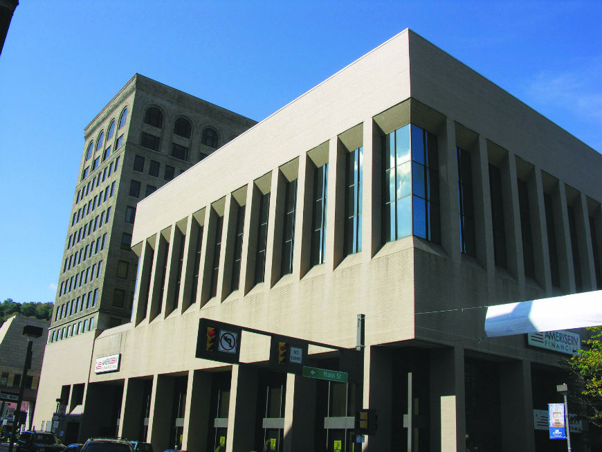
Your tour begins on the site of the former Swank building, which stood from 1907 through 2005. Today it is a 1st Summit Bank, at the corner of Main and Bedford Streets. GIS coordinates are included for the sites on the tour for those using GPS devices.
To begin,download and print this downtown walking tour map, with markings to help you identify these historic structures. Each structure is represented by a contemporary image — where possible, we’ve also included a historic image.
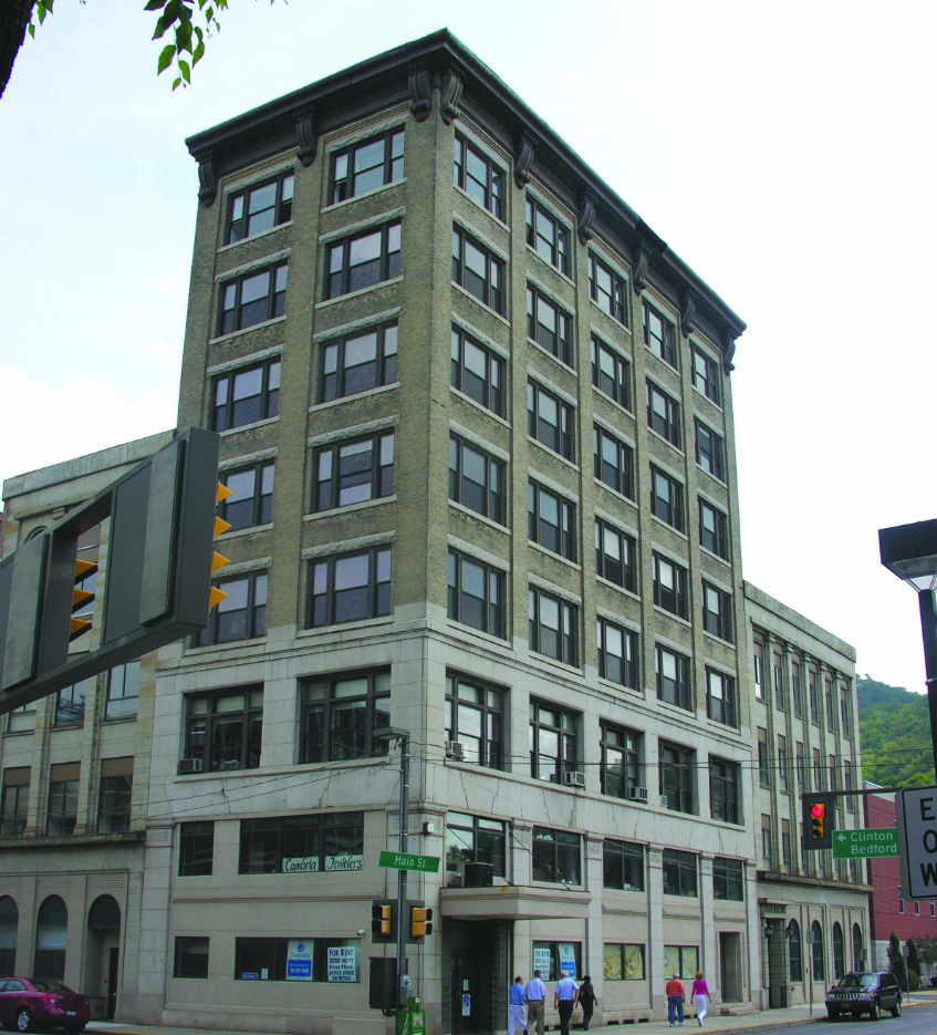
1. The Carnegie Building (ca. 1900), seven stories tall, was originally the Title Trust and Guarantee Building. This prominent downtown office building has a stone veneer on the first floor and a huge metal bracketed cornice. Latitude: 40.32442; Longitude: 78.91575
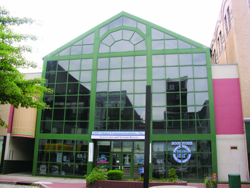
2. The Fisher Building (seen in right background) is a four-story modern office building was constructed ca. 1920. Latitude: 40.32416; Longitude: 78.91548
Built in 1893, this is one of the few surviving upper middle class homes in the downtown. Hamm was the proprietor of the Merchant’s Hotel on Main Street. The house combines Richardson Romanesque heavy stone construction, a wide stone arch over the entry, and a corner tower.Latitude: 40.32372; Longitude: 78.91493.32372
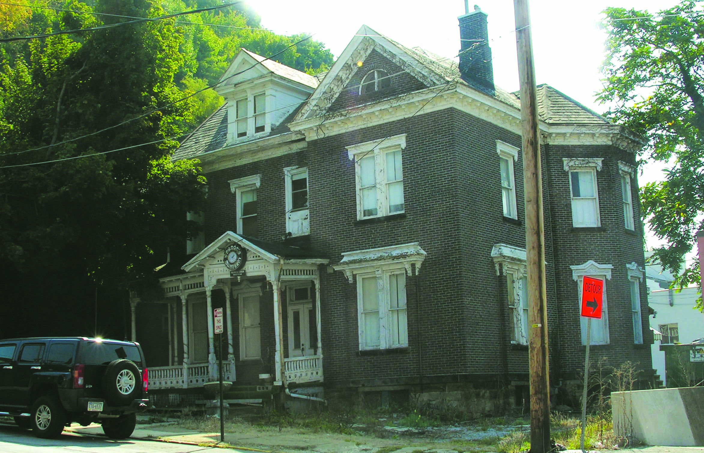
Formerly Gordon’s Mortuary, this 1883 residence was built in the Eastlake style, with wood columns and banisters, detailed window canopies and brackets, and a projecting pavilion. Latitude: 40.32490; Longitude: 78.91564
Built in 1892 by John Widmann, it was originally a grocery. The handsome Romanesque style building includes a rough sandstone exterior, buff and pink sandstone pillars, keystones, and stone belt courses. Latitude: 40.32523; Longitude: 78.91527
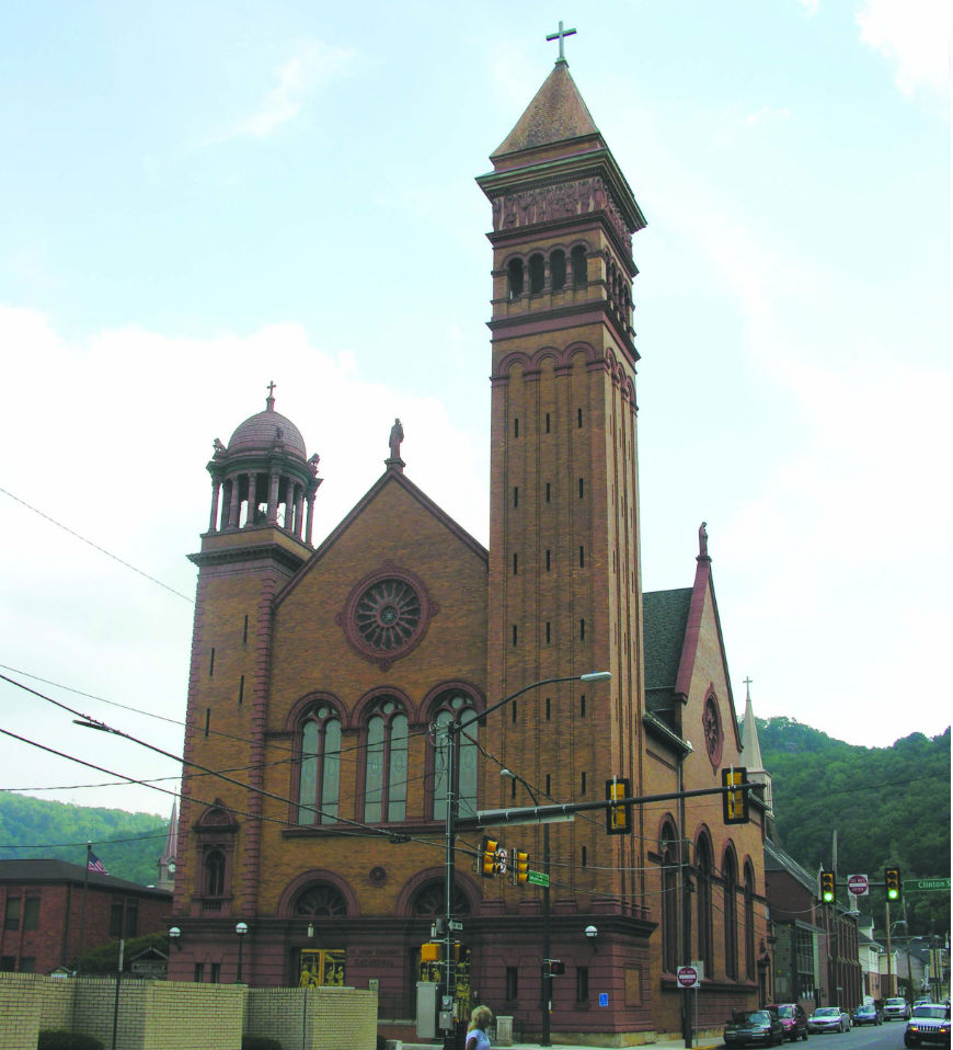
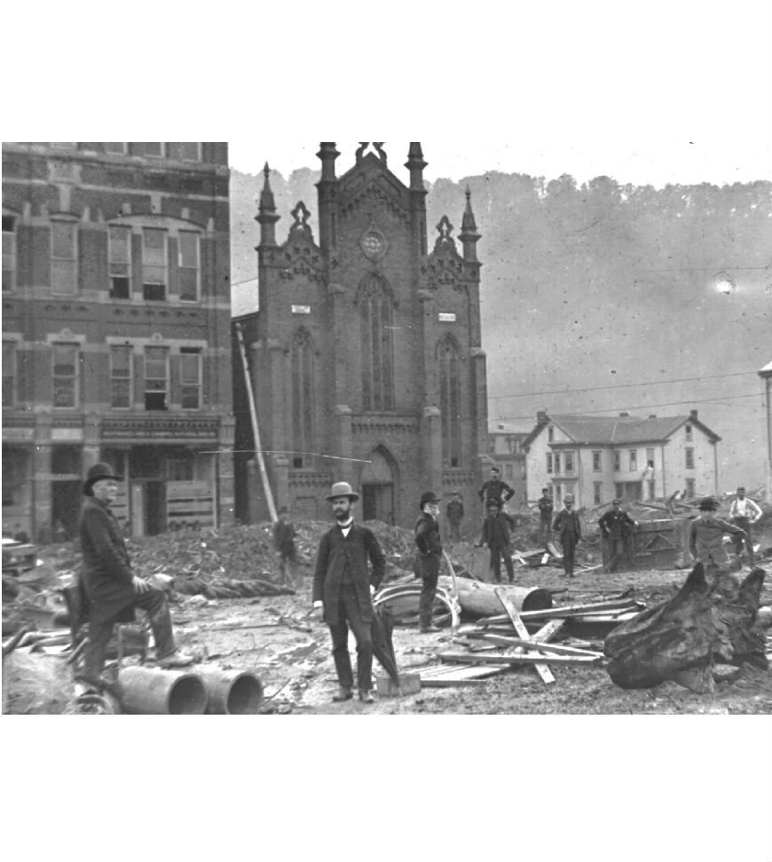
Completed in 1896, this is the most ornate of the downtown churches. It combines pressed brick, brownstone and rough faced terra cotta. Features include a wheel window, stained glass windows and a huge corner bell tower. Patterned after St. Mark’s in Venice, the church is one of the first examples of the use of structural steel in an ecclesiastical building.
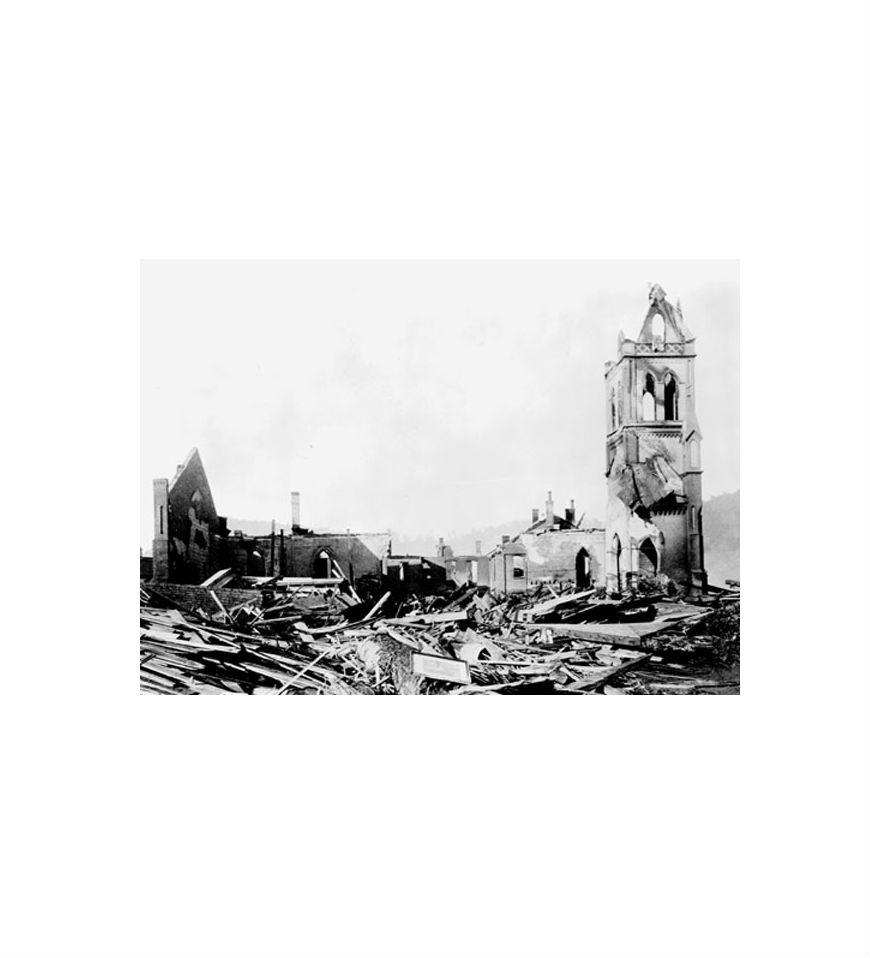
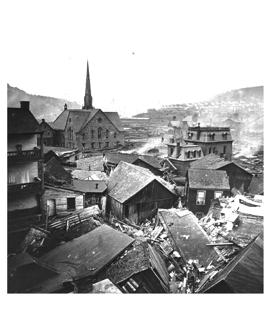
The church replaced the original St. John’s Church, which burned during the 1889 flood. the flood wave overturned dozens of houses that had coal stoves in their kitchens, and one of these crashed into the church with enough smoldering embers to ignite the structure above the water line. Latitude: 40.32538; Longitude: 78.91520
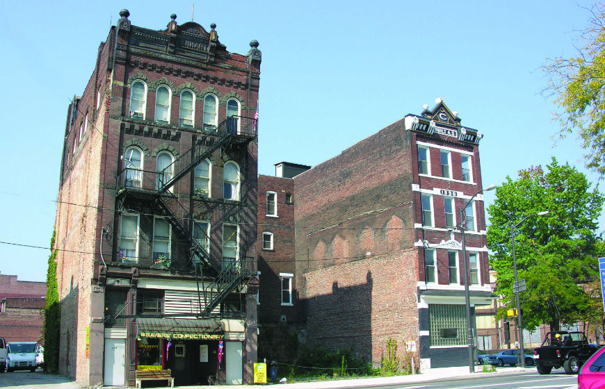
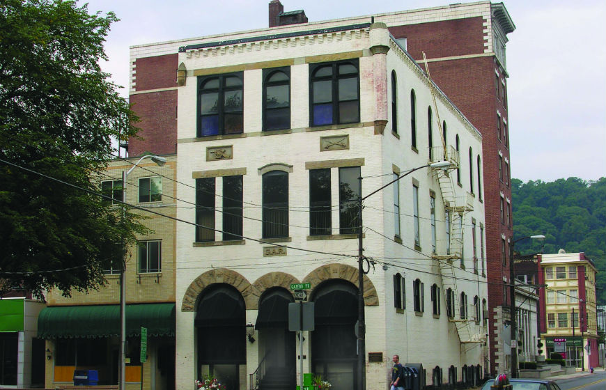
Built in 1890 by James Shumaker, the Penn Hotel (in the right of the image) building has decorative flower carvings in stone, cast iron trim along the roofline, and brick corbelling. The building features an intact cast iron storefront. Located near an entrance to the Gautier plant, this tavern would have been an active mill gate bar. Latitude: 40.32593; Longitude: 78.91527
The 1889 Lenhart Building i(on the left) ncorporates Romanesque details including rounded arches, metal cornice, and the original entryway. The building features an intact cast iron storefront. Latitude: 40.32570; Longitude: 78.91541
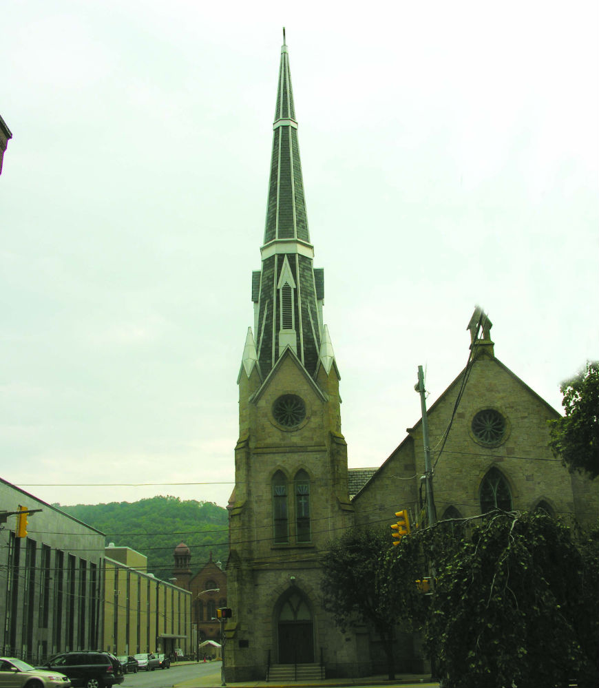
The only surviving downtown church that predates the 1889 Flood, the Franklin Street Methodist Church is famous for having split the flood wave, allowing several buildings on Main Street to avoid a direct hit. Latitude: 40.32567; Longitude: 78.91723
Built in the Gothic Revival style, its design is credited to mill designer and inventor George Fritz. Constructed in 1869, the stone church has a steeply pitched roof, an 80-foot-tall corner spire, pointed arch window and door openings, buttresses and rose windows.
The Reverend Henry L. Chapman, the church’s pastor in 1889, was preparing his Sunday sermon when a B & O Railroad car floated by in front of the parsonage. He rushed his family to the attic. They watched as the row of frame houses down the street were whisked away by the flood waters. “Pale, frightened, and awestricken,” they waited through the long night, “expecting each moment to be swept away.”
The Chapman family survived mainly because their house stood close to the massive sandstone church, which took the brunt of the flood without a crack in its walls. The flood wave parted around the church, and continued on its path of destruction across town. Several other buildings that stood in its protection were still intact when the waters subsided.
Although no damage was done to the exterior, the church suffered serious damage inside. Water broke through the windows and poured into the sanctuary some 18 feet deep, causing the floor to cave in, ruining the plaster, and destroying the choir gallery and numerous pews.
Later, a Citizen’s Committee in charge of reconstruction ordered the church dynamited and cleared away. Fortunately, the commander in charge of relief troops, recognizing its significance in protecting lives and property, placed a guard around the church to save it until the committee reconsidered that decision.
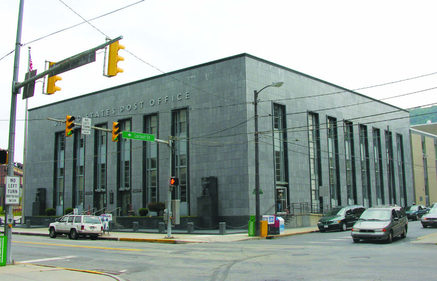
The 1938 Johnstown Post Office is a notable Art Moderne designed by Lorimer Rich, and still serves as the post office today. It features a smooth black stone facade, vertical window bays, and iron window frames. The stylized eagle sculpture was a New Deal/WPA art project. Latitude: 40.32606; Longitude: 78.91712
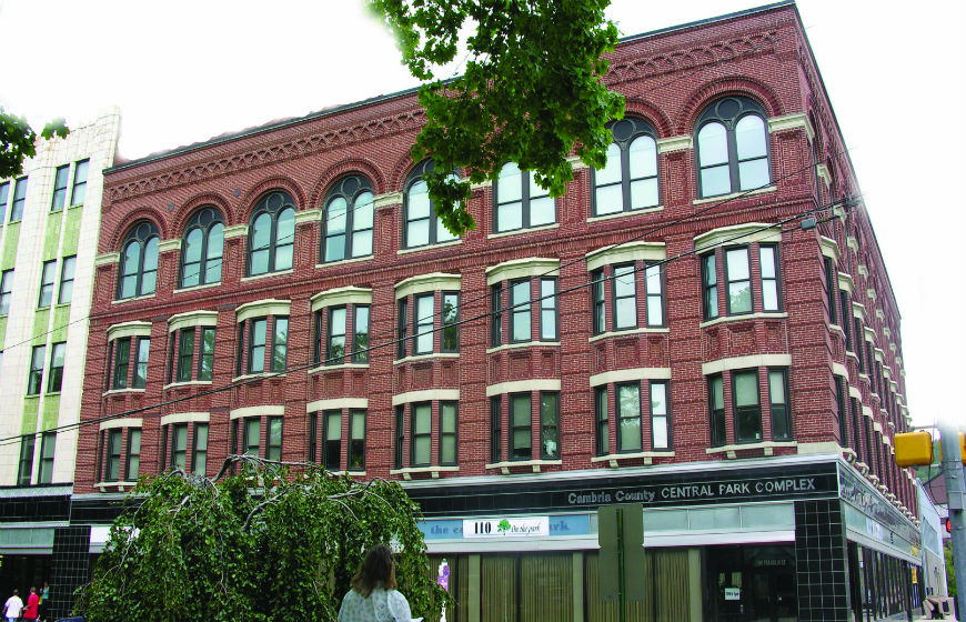
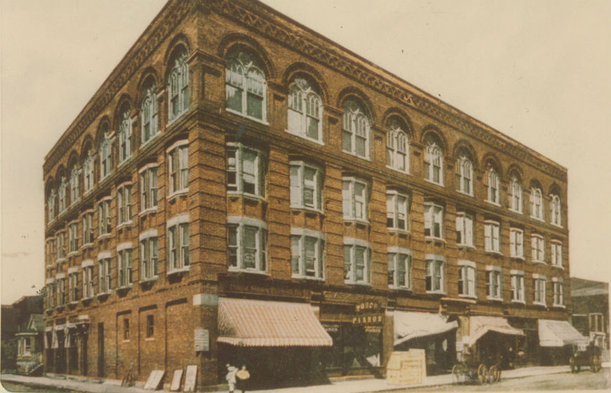
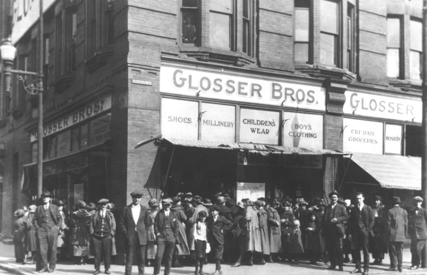
The oldest department store building remaining in Johnstown, the Ellis Building was constructed in 1905 in the Romanesque style. Louis Glosser established a tailor shop on the first floor in 1906. It is distinguished by a brick colonnade at the roofline, rounded windows, decorative arches, decorative brickwork, pilasters and projecting bay windows. The 1931 Art Deco addition features vertically aligned window bays and glazed terra cotta incorporating shell and plant motifs. Today the first floor is home to the Press Bistro, a popular restaurant for casual dining. Latitude: 40.32613; Longitude: 78.91760 (The historic image is of a ca. 1910 postcard).
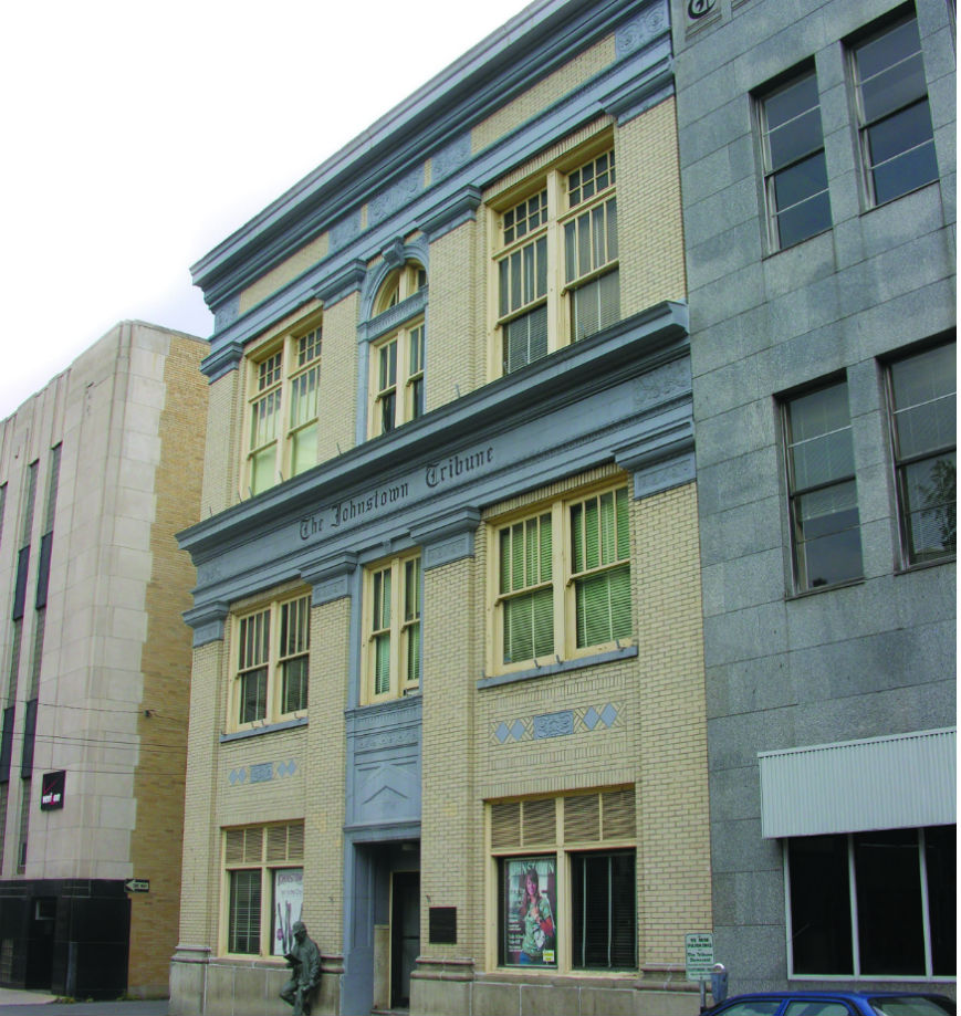
The Tribune-Democrat Building was built in 1919, and features Classical Revival details. The annex was constructed ca. 1940. Latitude: 40.32633; Longitude: 78.91832
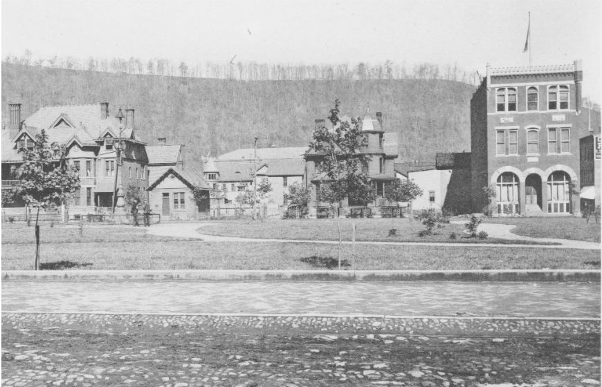
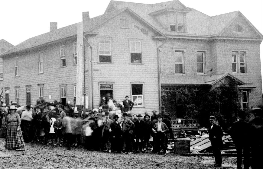
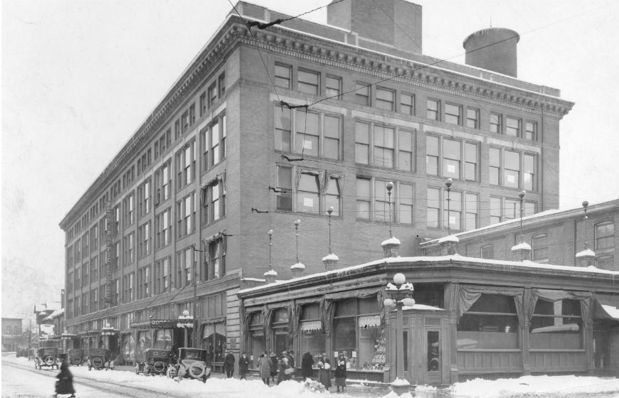
The Grand Army of the Republic chapter, which once had more than 300 members, constructed this building in 1893. It features Romanesque details including heavy round stone arches and carved stone sculpture representing military hardware including artillery, cannon, swords and bullets. The second photo in the slider dates from 1895, and shows the GAR Building on the right, with Central Park in the foreground. Latitude: 40.32622; Longitude: 78.9186914.
The 1913-14 Mayer Apartment Building (tall brick building in background of the contemporary photo), which was designed by Johnstown architect Walter Myton, is an eight-story structure with terra cotta classical details including keystones, cornice, and storefront pilasters. Latitude: 40.32636; Longitude: 78.91897
The 1913-14 Mayer Apartment Building (tall brick building in background of this photo), which was designed by Johnstown architect Walter Myton, is an eight-story structure with terra cotta classical details including keystones, cornice, and storefront pilasters. Latitude: 40.32636; Longitude: 78.91897
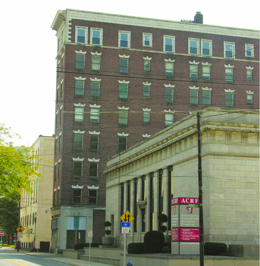
Designed by James Knox Taylor, the 1912 Old Johnstown Post Office building (grey structure in the foreground) incorporates a Classical Revival design. This terra cotta building is built in temple form, with simple Doric columns, full classical entablature and four brass plaques representing the seal of the President, the Commonwealth of Pennsylvania, the U.S. Department of Justice, and the U.S. Postal Department. Formerly the Johnstown Post Office, it now houses the offices of the Alternative Community Resource Program. Latitude: 40.32650; Longitude: 78.91930
Dating from 1925, the Public Safety Building represents modern office building construction, with clean lines and minimal architectural detailing. Ornamentation includes bas relief eagles and hard pressed brick walls. Latitude: 40.32757; Longitude: 78.91890
The five-story Penn Traffic Department Store building (1906-08), is attributed to the Buzer Bros. construction firm of Pittsburgh. Additions were made in 1924 and 1949. It is the downtown’s largest structure, a block long edifice distinguished by classical ornamentation. The ornate Renaissance design features Indiana pressed brick walls and semi-glazed white tile details. The Penn Traffic Co. store, which closed after the 1977 flood, was the successor to Wood, Morrell & Co., the Cambria Iron Company’s “company store.” The building, which is now used as an office building and federal court, occupies an entire city block. Latitude: 40.32776; Longitude: 78.91939
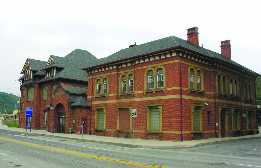
The business center of the Cambria Iron Company’s empire, this office building is a survivor of the Johnstown Flood. Its two sections, built in 1881 and 1885, reflect the changing popularity of architectural styles. The oldest section (western) is Palladian with its symmetry, hip roof, stone belt course, and stone window surrounds. The later section (eastern) has a contrasting Queen Anne design with asymmetrical massing, large dormers, and brownstone details. The building was designed by Addison Hutton, a prominent Philadelphia architect.
Johnstown was a company town in 1889. Some 7,000 men and women worked for Cambria Iron Company, and many of them rented one of the 700 company houses throughout the Conemaugh Valley. Groceries and supplies were purchased at the company store, and medical attention could be obtained at the company-financed hospital. Cambria Iron Company could afford such benevolence because at the time of the flood its holdings were well over $50 million.
In addition to being one of the world’s leading steel producers, the company owned many collateral interests. Among these were thousands of acres of mineral lands, 35 miles of railroad track and some 1,500 railroad cars. The company also held extensive real estate, such as a theater, a company executives’ club, shoe and furniture stores, wire, flour, and woolen mills, and several farms located on surrounding hillsides.
This general office building is one of the few structures on this street that survived the 1889 flood. However, it was the Iron Company’s large, three story department store that bore the brunt of the massive impact of the flood wave. The wave tore out an entire wall of the store but left the company’s office building intact. Latitude: 40.32812; Longitude: 78.92017
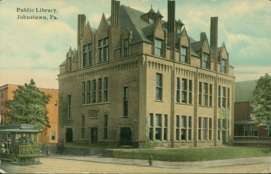
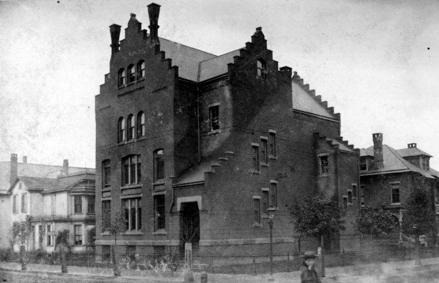
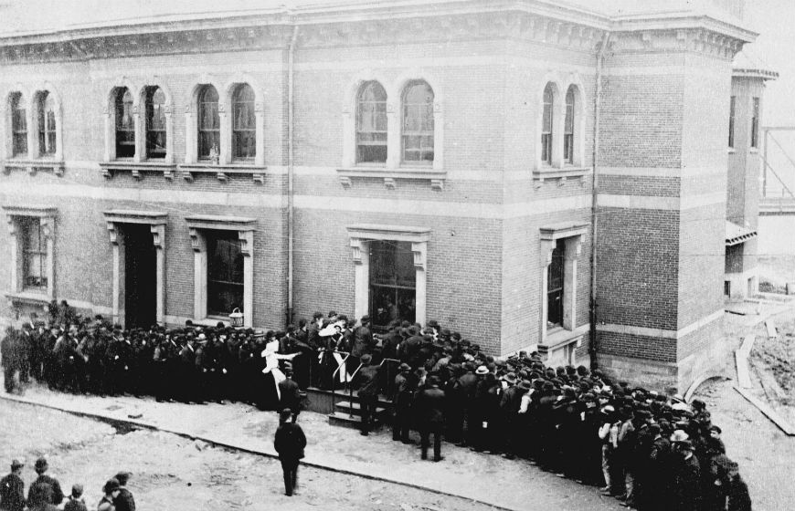
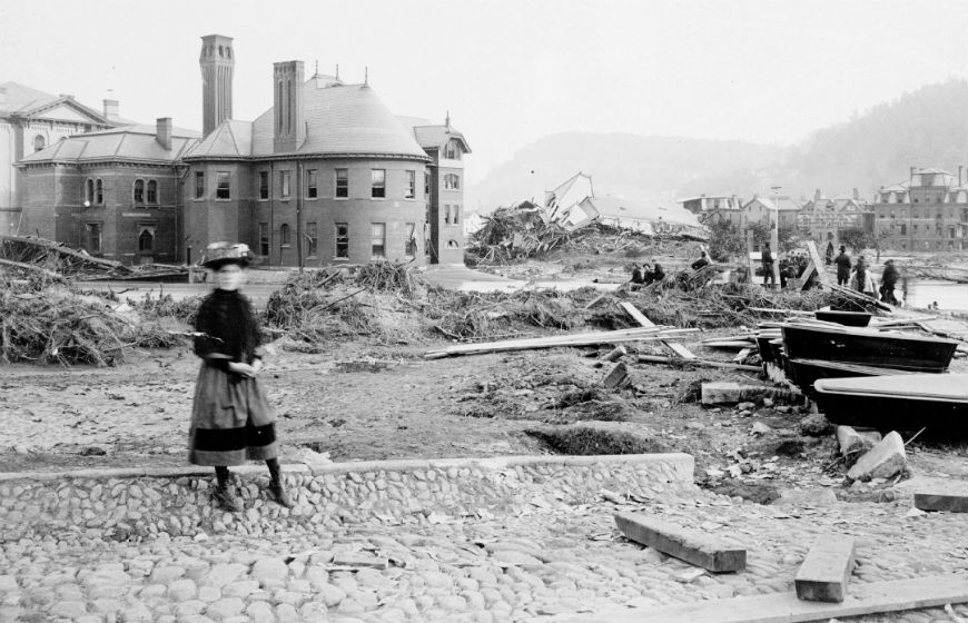
This French Gothic style library was designed by the Philadelphia architect Addison Hutton. The oldest public building in downtown Johnstown, the Cambria Free Library was built in 1892. The two and one-half story French Gothic design is distinguished by its steeply pitched hipped roof, pointed dormers, slate roof, narrow windows and battlements. (In the slider above, you’ll find a contemporary photo of the museum, an early 20th century postcard of the building, and an image of the pre-1889 library, which was destroyed in the flood. The new library was constructed on the same plot of land).
The building occupies the site of the former Cambria Library, which disappeared in the flood waters, along with its librarian. Four months after the devastating flood, Andrew Carnegie journeyed from Pittsburgh to visit the local steelworks and see the ruins of Johnstown. Carnegie donated the money to erect a new library on the same site. One of the nation’s richest men, he was better known in Johnstown as a member of the South Fork Fishing and Hunting Club. The club was responsible for the South Fork Dam, which gave way and sent 20 million tons of water rushing onto the city of Johnstown and the Conemaugh Valley.
The new building was similar to Johnstown’s first library, which had been financed by the Cambria Iron Company. Like its predecessor, the new Library contained 8,000 standard works and had spacious, comfortable reading rooms. Its large, first floor auditorium was used for town meetings. On the third floor there was a gymnasium which included a large exercise track made of padded leather. The library proper was on the second floor.
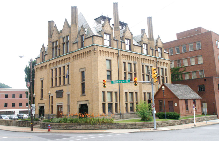
In 1973, the public library moved to a new building, and this structure became the Johnstown Flood Museum. It is listed on the National Register of Historic Places and was restored in 1989. Latitude: 40.32788; Longitude: 78.92063
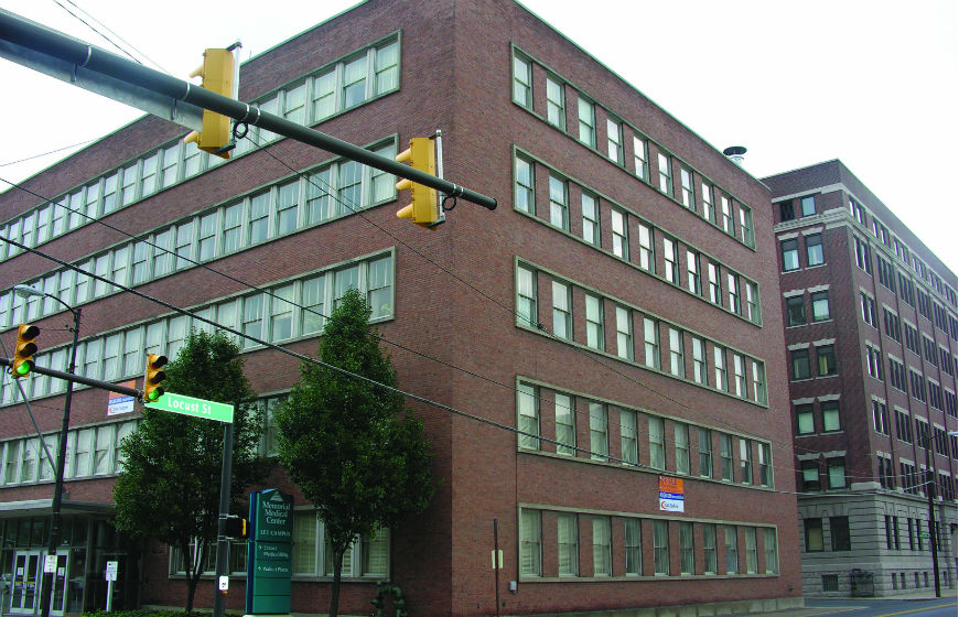
Built ca. 1950, this modern office building was designed by the firm of McKim, Mead & White. Located behind it at 333 Locust Street is the steel company’s 1911 office building. Latitude: 40.32749; Longitude: 78.92109
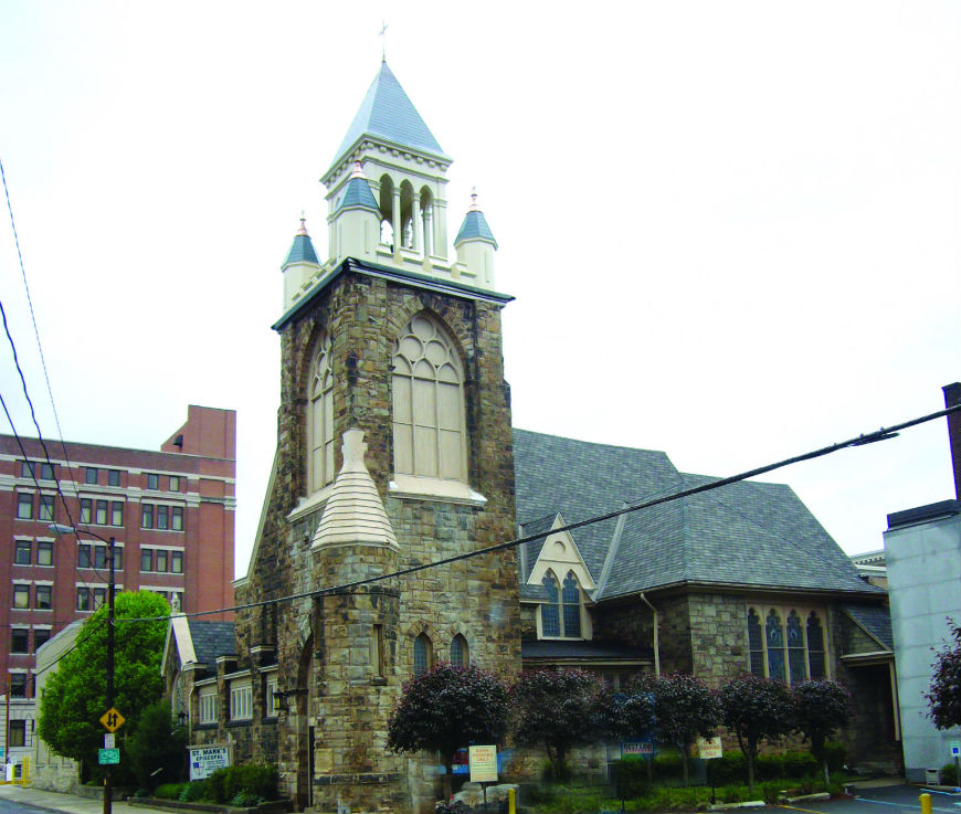
Erected in 1891, this Gothic Revival style church features a corner steeple, pointed arch windows and doorways, and battlement-like windows. It replaced an 1874 Episcopal Church that was destroyed by the Johnstown Flood, in which the pastor and his family died. The church bell and other items are relics from the original church.
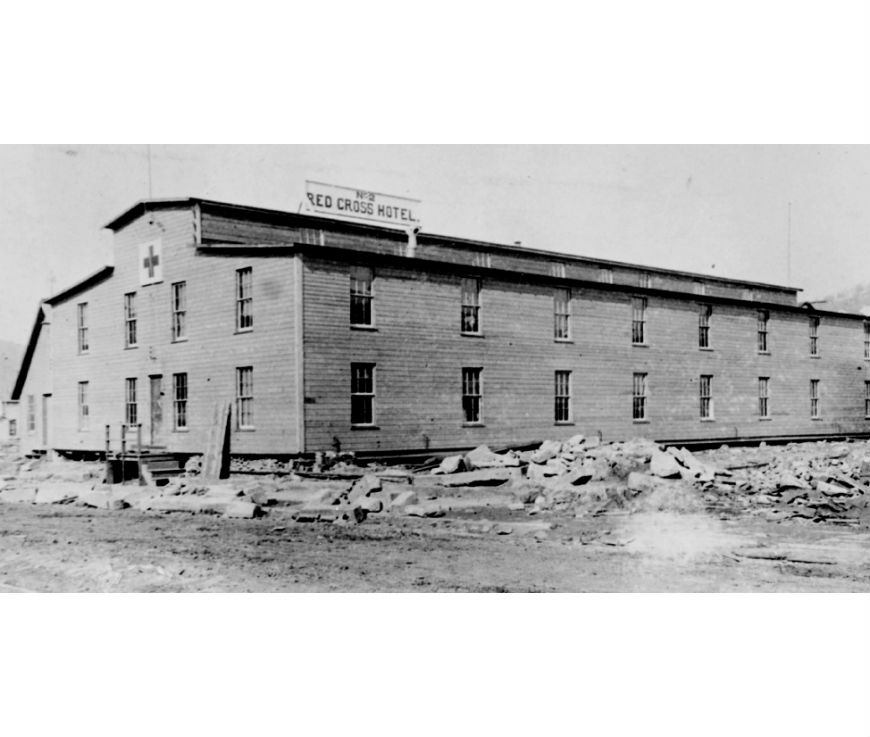
But before the new church was constructed, the site was the location of one of the Red Cross hotels. Responding to her first major disaster since the founding of the American Red Cross in 1881, Clara Barton arrived in Johnstown on June 5, 1889, accompanied by fifty doctors and nurses. At age 67, Miss Barton had abundant energy and worked relentlessly for the relief of the valley’s survivors. The Red Cross directly served over 25,000 victims of the Johnstown Flood.
Here, where St. Mark’s Episcopal Church now stands, the Red Cross built a hotel for “the wealthy, the elegant, the cultured leaders of society, and the fathers of the town.” After finding many of these men homeless and working long hours in the mud and rain to help in the grueling clean-up, Miss Barton reasoned: “As the salvation of the town depended in great measure upon the efforts of these men, it was vitally necessary that their lives should be preserved. . .”
The “Locust Street Red Cross Hotel” was constructed in fast order. On the outside, the hotel looked much like the large Red Cross warehouse only 50 yards away, but on the inside it was homelike and comfortable. It had hot and cold running water, gas heat, and furnishings donated by companies from far and near. (An image is included in the slider)
The Red Cross relief effort continued in the valley another two months. Clothing, medicine, furniture, and domestic supplies were freely distributed to all flood refugees. This was the first real test of the newly organized Red Cross. Latitude: 40.32692; Longitude: 78.91964
The State Theater, built in 1926, was advertised as Johnstown’s first “million dollar theater.” The theater features a glazed terra facade. The balcony has been reused as an auditorium. Latitude: 40.32605; Longitude: 78.92067
The Joseph Johns plan set aside public spaces on all four corners of this intersection. Parks still occupy three sides, with City Hall occupying the fourth. Latitude: 40.32585; Longitude: 78.92003
Built around 1890, this Second Empire style building retains decorative molded wood lintels, metal “shingle pattern” roofing, and a bracketed cornice. It retains its original use pattern, with two retail shops on the ground floor and apartments above. Latitude: 40.32526; Longitude: 78.92031
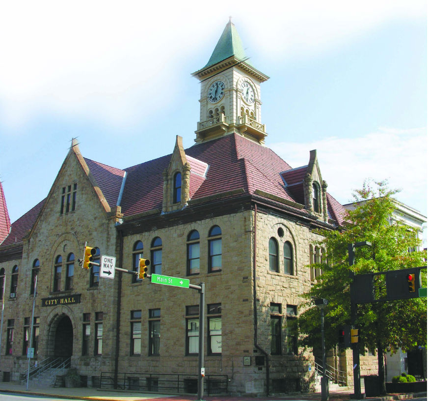
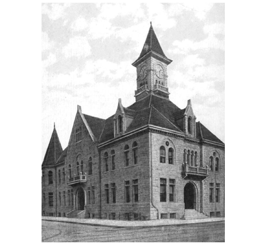
Constructed in 1900 to replace an earlier municipal building on this site, City Hall is attributed to Walter R. Myton and Charles Robinson of Altoona. This landmark incorporates a Richardsonian Romanesque design with a central tower. Myton went on to design numerous residences, churches, stores, and schools in Johnstown.
The new City Hall held special significance for the community. Here one of the flood’s most beneficial changes to the town took place – the consolidation of many of the valley’s small boroughs into the City of Johnstown. Before the flood, each borough guarded its governing rights. The survivors of these small communities were united by the flood in a bond of common cause and grief. Rebuilding together made sense, and consolidation was approved by voters in on November 6, 1889.
Markers on the wall of City Hall show high water lines during Johnstown’s three worst floods. Flood control measures were taken after the 1936 disaster, yet in 1977, a “once in 500 years” storm caused a flood resulting in 85 deaths and $200 million in damage. Latitude: 40.32605; Longitude: 78.91958
Completed in 1920, this Beaux Arts style building was built for the Farmers Trust and Mortgage. Later, it was used by the Johnstown Savings Bank and the Moxham National Bank. Latitude: 40.32590; Longitude: 78.91914
This Presbyterian Church was dedicated in 1866, located midway along Johnstown’s principal business row. The pastor of the church, Reverend David J. Beale, lived in the new parsonage behind the church with his wife and children. The Beales, after the flood wave hit, climbed out over the wreckage and found refuge at Alma Hall. Both the church and the parsonage were spared. Although the church was still intact, it was greatly damaged inside by the water that submerged all its pews.
For weeks after the flood, the church served as one of the valley’s six temporary morgues. As bodies were found, they were brought to the church, where volunteer undertakers from Pittsburgh and other parts of the state embalmed them. Special care was taken to record any recognizable features. Clothing was also described to help survivors identify lost family members.
Many of the dead were beyond recognition when they were pulled from under debris. Of the 2,209 total dead, 755 remained unidentified. These lie in a special memorial plot dedicated to the Unknown Flood Victims in Grandview Cemetery.
During the early 20th century, this church was converted for use as a theater — first the Nemo and later the Embassy. The facade of the old church is incorporated into the Lincoln Center complex. Latitude: 40.32552; Longitude: 78.91932
The Garden Theater (later Park) was built ca. 1913. Designed by popular local architect George Wild, the building housed a theater on the first floor and offices above. The building features tile mosaics, inset masonry elements, and Doric pilasters. Latitude: 40.32573; Longitude: 78.91891
Built in 1917, this store was designed by Pittsburgh architect Charles Bickel. The Early Modern design features brick exterior walls, Chicago style windows, glazed terra cotta details, and a classically styled cornice. The adjoining annex, built in 1920, features fanciful terra cotta panels along the cornice lines. Nathan’s Department Store is known as Central Park Commons today. Latitude: 40.32526; Longitude: 78.91897
Built by the Independent Order of Odd Fellows in 1884, this Queen Anne style landmark is the oldest building constructed by a fraternal organization in the downtown district. It is still the headquarters for Alma Lodge 523 of the Independent Order of Odd Fellows (I.O.O.F.).
Shielded by the Methodist Episcopal Church, it survived the flood wave and gave refuge to 264 people during the night of May 31. This four story brick building was the tallest in Johnstown when constructed in 1884 in the Queen Anne style. Its decorative facade treatments include incised artwork on inset stone blocks, elliptical brick arches, and corbelled brickwork. Office space was rented out on the first and second floors. The third and fourth floors contained meeting halls.
After the flood hit, the first floor was under water. Survivors from all over the valley were swept into the vicinity of the building. Many struggled over the wreckage, submerged in water 18 feet deep, and climbed into the Hall through second story windows. James M. Walters, a Johnstown lawyer, was thrown into his own office window when the rooftop he was on crashed into the building. While it was still light, some men in the Hall took a rope and went out on the wreckage to help rescue other survivors. Walters was elected as director of the building and along with three other men was placed in charge of the hundreds of people gathered on the second to fourth floors.
Women and children were made as comfortable as possible, and prayers were led by Reverend David Beale. Strict orders were given that no one was to turn on any of the gaslights, for fear that escaping gas might cause the building to explode.
Alma Hall sheltered some 264 people during the night following the flood. In the course of the night two babies were born. Suffering from three cracked ribs, Dr. William Matthews did his best to attend to these newborns and numerous other survivors with injuries.
The threat of the surrounding water crushing the building was ever-present through the long night. By morning, one survivor had died. Those who were able climbed out a window and struggled their way across acres of debris to the safety of Green Hill. Latitude: 40.32517; Longitude: 78.91857
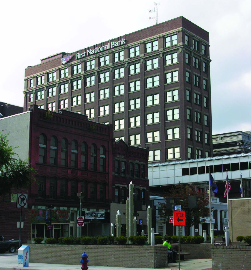
The older 10-story United States Bank Building (1910), located at the rear, exemplifies the downtown’s development as a financial and office center. A modern building in the Brutalist style occupies the corner of Franklin and Main streets. Latitude: 40.32511; Longitude: 78.91826
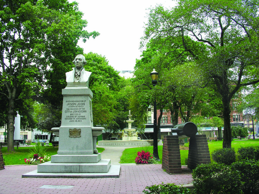
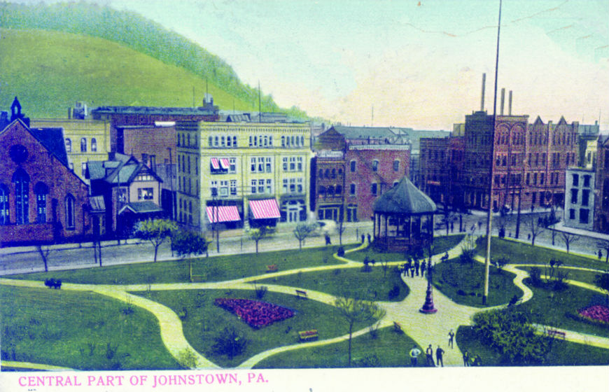
This park was designated as public space by the town’s founder, Joseph Johns, when Johnstown was first chartered in 1800. By the mid-l9th century, a firehouse, butcher shop, jailhouse, and a large market stood here on the public square. In 1833, the first circus in Johnstown was held in the Park. During the Civil War, soldiers used Central Park as a drill field. Children came with their parents to see circuses or watch the town’s two baseball teams, the “Kickenapawlings” and “Iron Club,” practice.
In 1872, the grounds were cleared of all buildings and laid out as a formal park. There was an ornate water fountain in the center. Nearly 100 planted trees offered shade in the summer. It was a small, quiet oasis in a busy industrial town.
The years of landscaping were wiped out in seconds by the flood wave. When the waters receded, debris 10 to 15 feet high filled the park. Within four days the wreckage was cleared to make room for tents that would house the 14th Regiment from Pittsburgh.
After the troops departed, the park was lined with temporary wooden stores for about a year. The square was finally restored as a park, and new trees were planted. Today the park even includes a large, ornate fountain, donated by Frank Pasquerilla and very similar in style to the original fountain from the 1880s.
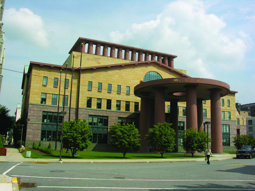
Architect Michael Graves designed the Crown American Building, which was constructed in 1989. Its classically inspired style enhances the character of the historic district. Graves also designed the interior furnishings and appointments. Latitude: 40.32416; Longitude: 78.91949
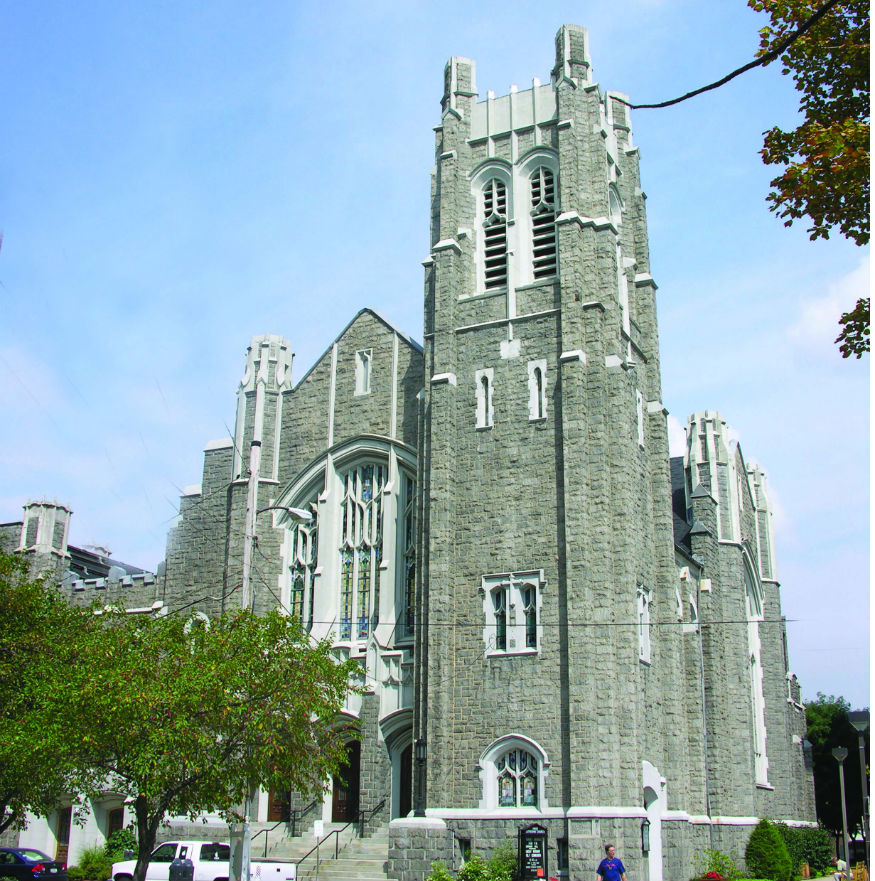
Constructed in 1920 in the Gothic Revival style, the First Lutheran Church features banks of pointed arch windows, a massive corner tower, buttresses, stained glass windows and stone facing. An earlier Lutheran church sited nearby on Franklin Street burned in 1918. Latitude: 40.32438; Longitude: 78.92022
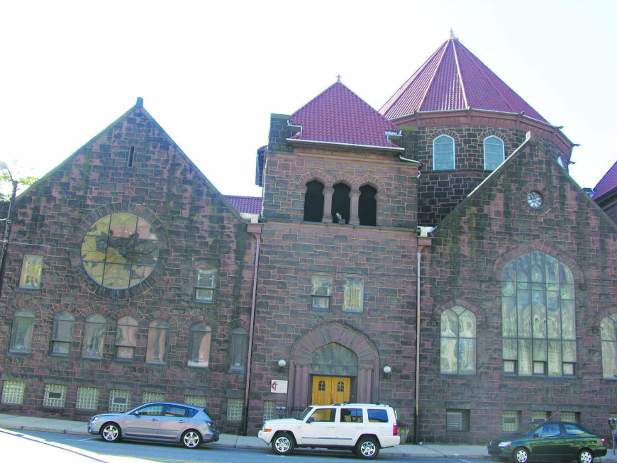
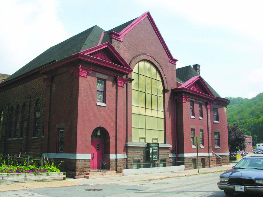
Erected in 1911, this rusticated brownstone landmark has a massive 90 foot center tower surrounded by gable and hip roofed pavilions. It has an Akron style interior, with the entrance in one corner and the pulpit in the opposite. The stained glass windows were produced locally by William Heslop. Latitude: 40.32375; Longitude: 78.91975
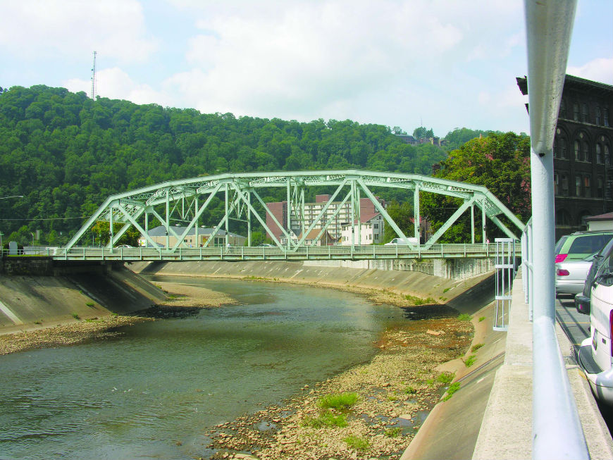
The Franklin Street Bridge was built in 1937 after an earlier bridge was removed by the 1936 flood. Latitude: 40.32369; Longitude: 78.91911
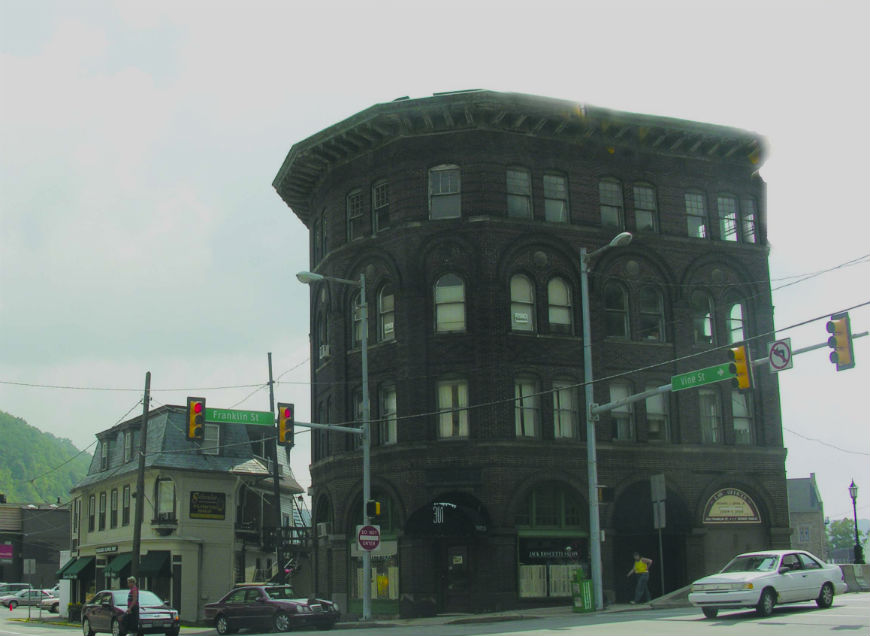
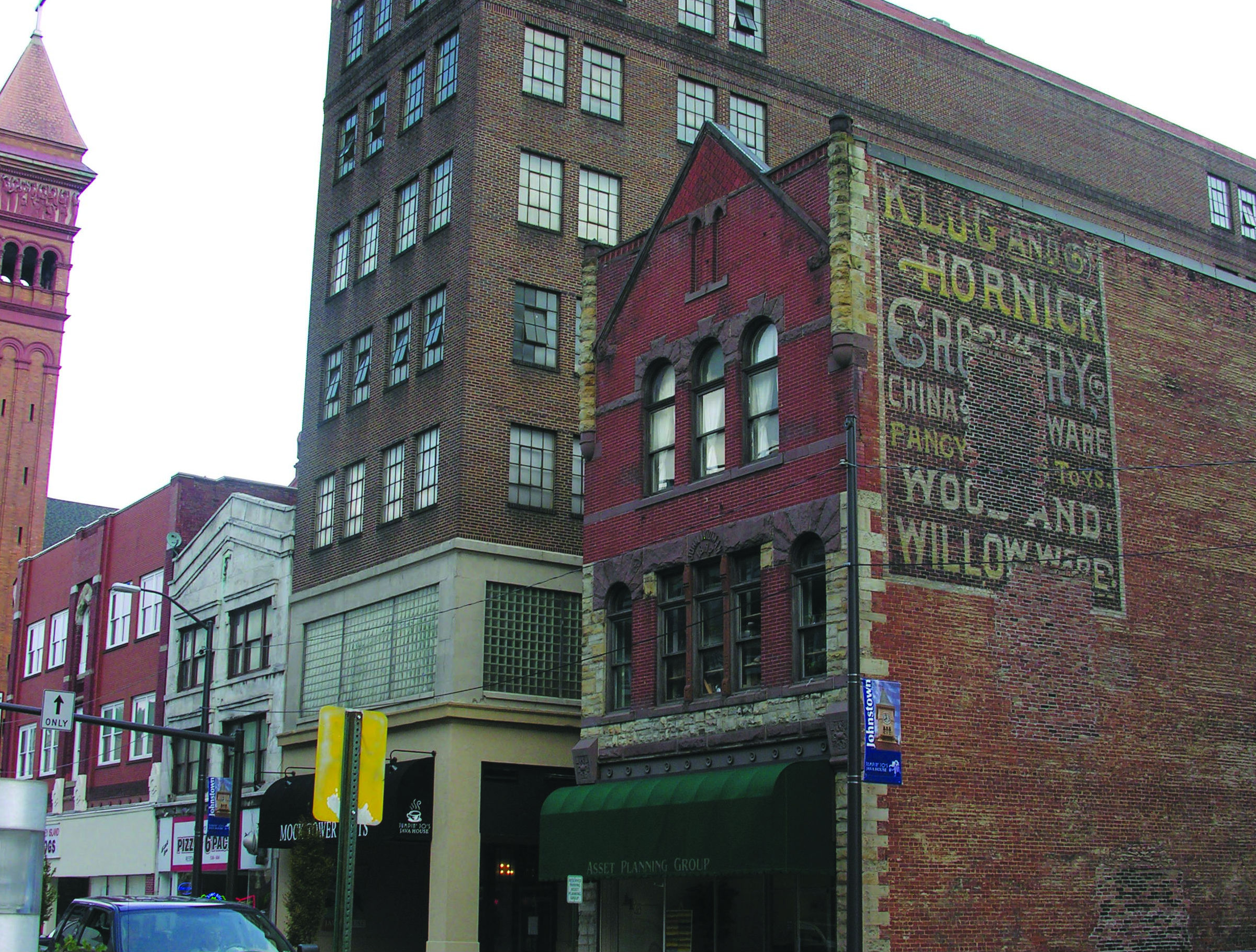
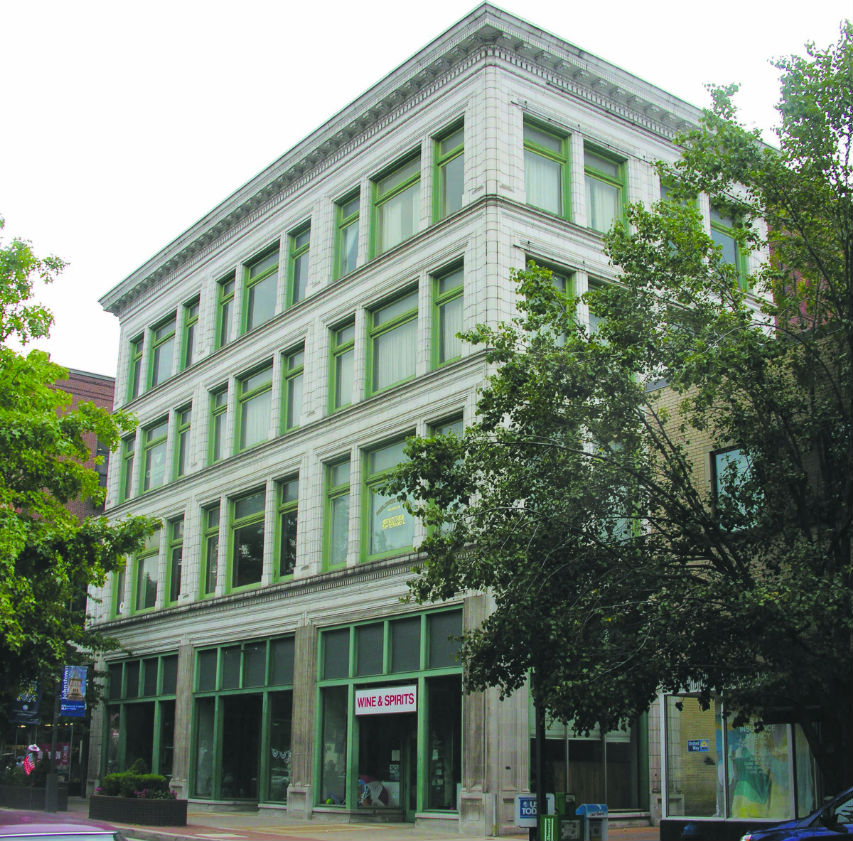
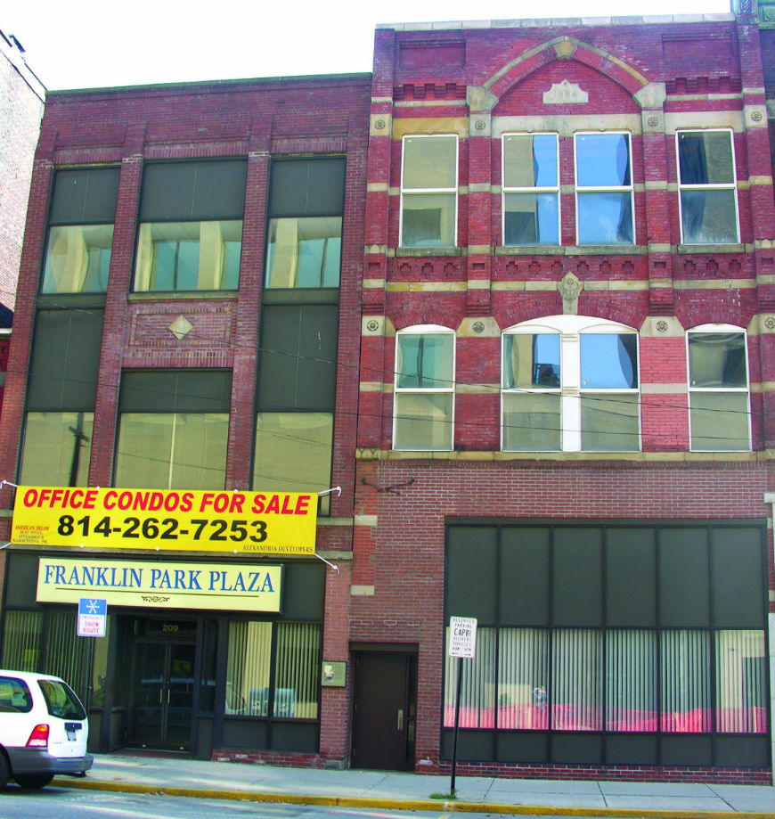
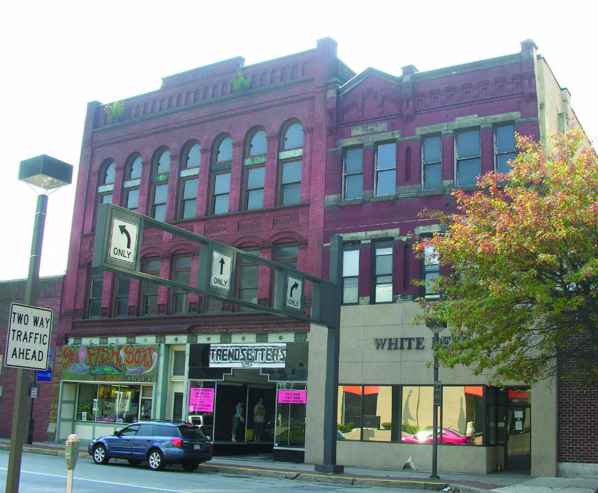
Beginning in the 1890s, the use of iron and steel framing, along with reinforced concrete, made it possible to build taller buildings. Built circa 1900,this four-story Conrad Building is a triangular shaped office building built in the Romanesque style. Its architectural features include a massive cornice, open round arches framing the doorways and windows, brick arcading over the upper floor windows, and decoratively patterned brick work. Latitude: 40.32368; Longitude: 78.91859
Located on the far right in the photo above is Johnstown’s most decorative Second Empire style building. This flower shop was built ca. 1890. It features a slate mansard roof, stained glass windows, and two small second story porches. Latitude: 40.32351; Longitude: 78.91812
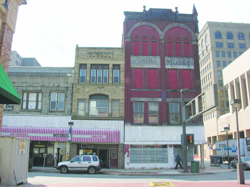
Dating from 1884, the BSG&G Investment Building is Gothic Revival style structure that survived the Johnstown Flood. It was originally the Moses Tailor Shop. It has a fleau de lis incised in stone and an elliptical arch.Latitude: 40.32448; Longitude: 78.91822
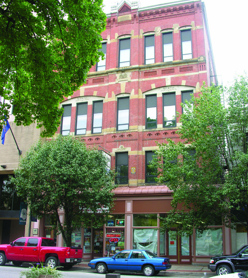
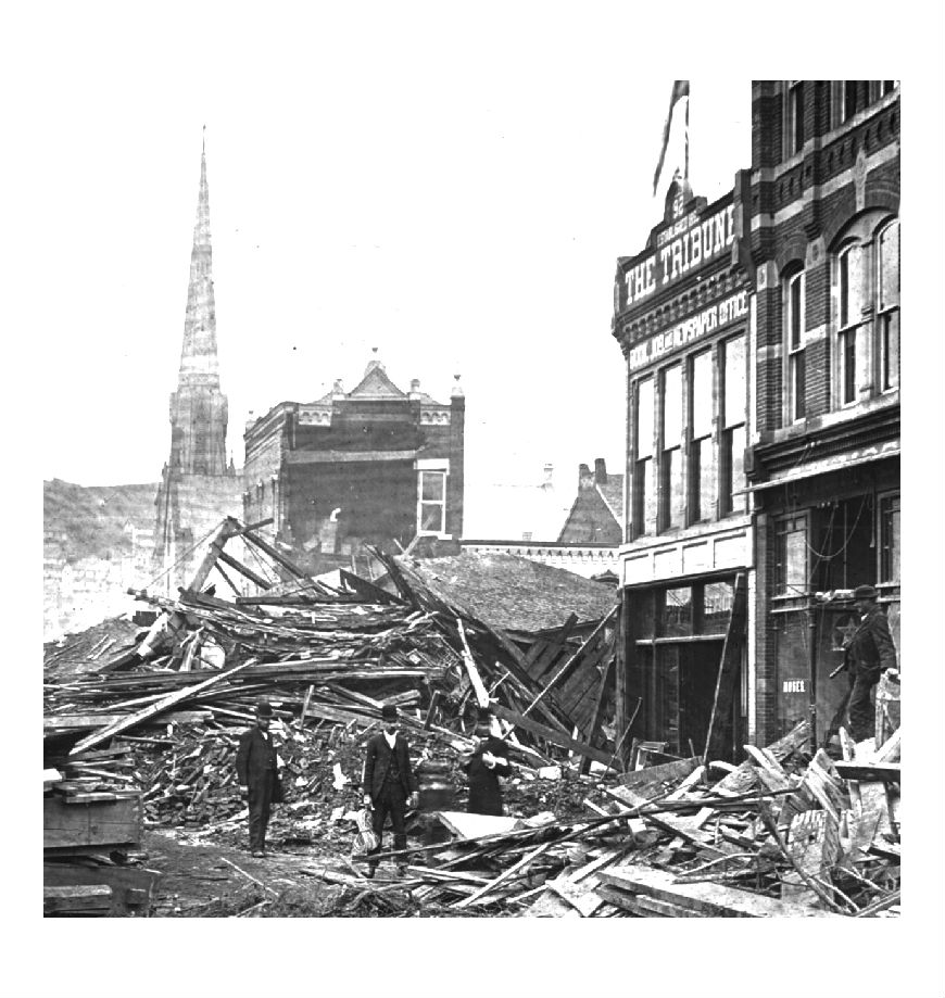
The former Tribune building, built in 1883, is a survivor of the Johnstown Flood. On the rainy Friday of May 31, 1889, George T. Swank, editor and publisher of the Johnstown Tribune, was preparing the weekly issue of the paper on the second floor of this building. At 2:30 p.m. he noted that the water stood about a foot deep on Franklin Street and that the current was flowing from Stonycreek River toward Main Street at about 6 miles per hour. Downstairs, the Tribune staff had given up trying to print the newspaper and was restlessly awaiting the recession of the waters, as was the rest of Johnstown.
Swank received a call at 3:15 p.m. from the Central Telephone Office reporting that South Fork Dam was “getting worse all the time, and the danger of it breaking was increasing momentarily.”
Swank had soothed the fears of Johnstowners about the South Fork Dam for years. If it were to break, he assured, it would cause little damage because it would spread out over the valley floor. But even Swank now felt grave concern. “It is idle to speculate,” he wrote, “what would be the result if the tremendous body of water . . .should be thrown into the already submerged Conemaugh Valley.” The lake water was tearing out of the broken dam on its way to Johnstown when Swank was writing the above quote.
When the flood wave hit downtown at about 4:10 p.m., Swank could see buildings “melt like sugar in fire.” The Tribune men, after being warned of danger by a cracking partition wall, ran into the adjoining building just before part of the rear wall of the print shop collapsed. The men spent the night on the roof in the cold and rain, in the flickering glow of a fire that burned on at St. John’s Church. Latitude: 40.32483; Longitude: 78.91798
This Italianate style commercial building (right) was constructed in 1889. It was begun by David Dibert, who perished in the Johnstown Flood, and completed by his son Scott. It features arches at the third and fourth floors, arched windows, incised brickwork, tapestry brickwork, a corner turret, and an intact cast iron cornice. Latitude: 40.32489; Longitude: 78.91781
Built in 1913, the J.T. Kelly is a narrow, three-story building that was originally a cafe (it is on the left in this image). Built in the Romanesque style, it features rusticated stonework, small marble columns, and stained glass windows.Latitude: 40.32484; Longitude: 78.91755
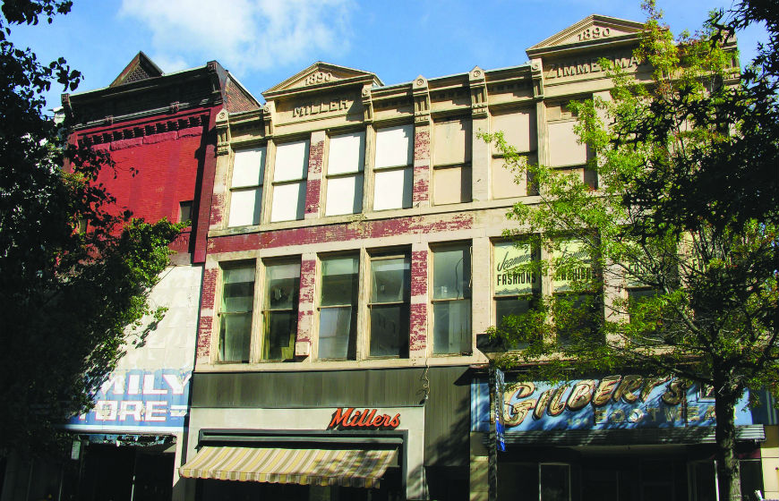
The Miller-Zimmerman Block (ca. 1890) was built to house a tailor and menswear shop by Miller and studio space for Zimmerman, a photographer. It still houses retail shops. Note the original, ornate metal cornice. Latitude: 40.32506; Longitude: 78.91713
Built in 1883, the Stenger Dry Goods Store (now The Family Store) features brick corbelling, pilasters, and an elaborate metal cornice. Latitude: 40.32506; Longitude: 78.91757
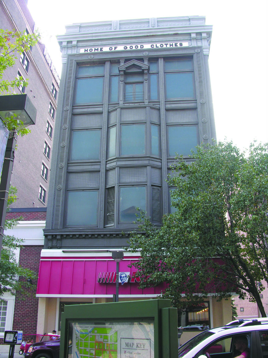
This building served as a popular men’s clothing store for many years. The building has a molded metal facade with Classical Revival decorative features and Chicago style windows. Note the slogan “Home of Good Clothes.” Latitude: 40.32451; Longitude: 78.91671
This ten-story bank and office building was built in 1915, and features a massive cornice in the Classical Revival style. Latitude: 40.32435; Longitude: 78.91633

Built in 1888 by Gottlieb Bantley, the Flood-surviving building is distinguished by decorative brickwork and stone lintels and sills. Some of the commercial structures on Main Street survived the Great Flood because the buildings were so close together that they supported each other against the force of the water. However, the debris in the street was piled up to the second story windows, and it took weeks and thousands of workers to clear the streets and make the buildings safe for use again. Latitude: 40.32426; Longitude: 78.91617
This 3-story Romanesque style building is distinguished by its highly detailed brickwork, round arches, decorative tiles, and the blind arcade at the cornice level. Latitude: 40.32435; Longitude, 78.91617
Built ca. 1910, this Romanesque style building features red brick walls and Classical Revival ornament. Latitude: 40.32342; Longitude: 78.91578
Built ca. 1900, this building is an example of vernacular commercial design during the late 19th century. The four story structure’s only decorative element is an arcade of window arches on the top floor and brick corbelling. Latitude: 40.32295; Longitude: 78.91565